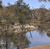
Avon River
|
The Avon River flows right through town and there is a picnic area on the east side of the bridge.
The Avon River flows 240 km from source to mouth, where it becomes the Swan River. It can be seen from the top of County Peak. There are bridges across the river at Edward’s Crossing, Mt Kokeby, as well as in town. |
More information
Click on the link for Google Maps directions to the picnic area by the river in Beverley. Google Maps |
County Peak
|
About 35km from Beverley, County Peak was given its name when the first surveyors drew up the original counties for the Swan River colony in 1829. County Peak was the intersection of counties York, Howick, Grantham and Minto.
The peak is also known as Mt Quajabin. Quajabin is derived from the Aboriginal word Quabin, which means ‘good camp’. The hike up to the top is relatively easy but be sure to take adequate water and keep a look out for snakes. Click here for more information on County Peak. |
More information
All routes to County Peak are suitable for non-4WD vehicles, however the most direct route from Beverley is down Great Southern Hwy and left at Kokeby East Rd. Please consider current weather conditions as some roads may be closed during high rainfall events. Contact the Shire of Beverley for more information. |
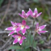
Nature Reserves
|
The nature reserves in Beverley provide a range of different wildflowers throughout the year. The best opportunity to see wildflowers is August to October.
Brooking Street Reserve is located within the town site. Click here for the map. Poison Hill Reserve is a short drive east of Beverley. Located on the corner of Aiken Road and Morbinning Road. Click here for map Dale River Reserve is located around 20km from the town site. A hotspot for native birds. Click here for map |
More information
When visiting these areas please take care and respect the surrounding flora and fauna. It is prohibited by law to pick any wildflowers. |
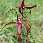
Wildflowers
|
You will discover a large range in wildflowers throughout the year. The most abundant time to see the wildflowers are in Spring from August to October.
The orchids are particularly amazing at the Brooking Street Reserve. Share your finds on the WA Visitor Centre wildflower tracker. |
More information
When visiting these areas please take care and respect the surrounding flora and fauna. It is prohibited by law to pick any wildflowers. |
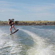
Yenyening Lakes
|
These large salt lakes are about 32km south east of Beverley.
All the water from the Lockhart and Yilgarn Catchments flow through the Yenyening Lakes and into the Avon River from an area of 91000 square kilometres. Yenyening Lakes are a haven for birdlife and are also used for water sports. Click here for more information on Yenyening Lakes. |
More information
All routes to Yenyening Lakes are suitable for non-4WD vehicles, however the most direct route from Beverley is down Great Southern Hwy and left at Kokeby East Rd. Please consider current weather conditions as some roads may be closed during high rainfall events. Contact the Shire of Beverley for more information. |